Weather! Alex churning in the Gulf, two more days of heat
Locally, we have only TWO MORE DAYS of hot weather before we get some relief. We set another record high of 102 Sunday, breaking the old record of 100 set in 1952. This marks the first time Richmond has ever hit 102 twice in June.
I’d like to start out with some good news for those of you living south of the river. An AWOS (Automatic Weather Observing System) unit at Chesterfield County Airport has been added to the National Aerospace Data Interchange Network. What does this mean for you? It means that the hourly observations taken by the system are now accessible online. You can find the last 24 hours’ worth of observations here: http://weather.noaa.gov/weather/current/KFCI.html. Unfortunately the temperature sensor at the station doesn’t seem to be very reliable.
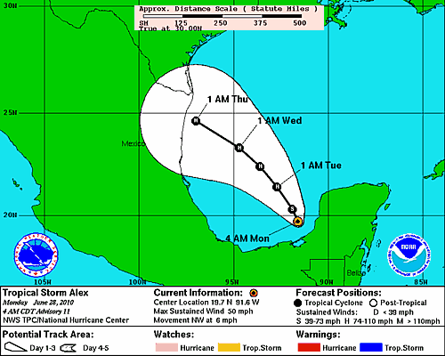
As I mentioned in the comments on Friday, the system that I was monitoring last week designated Invest 93L has been upgraded. What is now Tropical Storm Alex made landfall on the Yucatan Peninsula Saturday night, bringing heavy rain and strong wind to Belize and Mexico. It is back over water, now in the Bay of Campeche, and the forecast from the National Hurricane Center is for it to continually intensify as it tracks to the northwest.
If you’ve got travel or family in or near the forecast path, make sure you are monitoring the situation with Alex. The waters of the Gulf of Mexico are quite warm and will feed and intensify Alex until it makes landfall — more time before landfall means more time to strengthen. The NHC is forecasting Alex to reach major hurricane status (category 3 or greater on the Saffir-Simpson Hurricane Wind Scale) before it makes landfall. It’s important to note that there is still a lot of variability with regard to the track of Alex; the current projection is by no means set in stone. The average NHC forecast track errors at 3 days is 300 miles, so there’s quite a bit of variability still possible. The National Hurricane Center is providing updated advisories and forecast maps here: http://www.nhc.noaa.gov/#ALEX.
Locally, we have only TWO MORE DAYS of hot weather before we get some relief. We set another record high of 102 Sunday, breaking the old record of 100 set in 1952. This marks the first time Richmond has ever hit 102 twice in June. On Monday, temperatures will again soar into the upper 90s. An area of energy out ahead of an approaching cold front will be the trigger for some afternoon thunderstorms; some of these may be severe, with damaging straight-line winds. Tonight, low temperatures fall only into the mid 70s.
Monday Squirrelcast (7:05pm, vs. Akron): Hot, with a chance of a strong or severe thunderstorm this evening. First-pitch temperature will be in the lower 90s, falling to the low 80s by game’s end.
The cooldown begins on Tuesday, but only slightly, as temperatures again climb into the lower 90s. A cold front begins creeping south through the area on Tuesday, and the atmosphere should be relatively stable behind the front, keeping the chances of showers or storms to a minimum. Low temperatures Tuesday night begin to drop in earnest, falling into the upper 60s.
Tuesday Squirrelcast (7:05pm, vs. Akron): There’s no threat of rain for Tuesday, and game-time temperatures will be in the upper 80s. Enjoy partly cloudy skies as the temperatures drop to near 80 by game’s end.
The cold front clears the area by midweek. What’s behind it? How about highs in the 80s?! How about lower humidity?! They’re coming, you just have to hold on for two more days.
-
Recommend this
on Facebook -

Report an error
-

Subscribe to our
Weekly Digest


There are no reader comments. Add yours.