The week ahead: The temps, they are a-changin’
We’re kicking off the holidays right – with a lesson in satellite meteorology. The wind will do its best “annoying Aunt Nancy” impression for one more day before conditions become a bit more mild for Christmas Eve and Christmas Day. Got post-Christmas travel plans? Keep an eye on the forecast – things could get messy.

Astronomical winter began this morning at 6:12 EST. The winter solstice, the point where the sun reaches its lowest angle above the equator. While yes, winter has begun, here’s the good news: for the next six months, the days only get longer.
Let’s start with some satellite imagery:

For starters, here’s a look at a nationwide satellite image from this afternoon. While there’s a lot going on here, there’s two big features to focus on. One is the big storm system now centered over New York and Pennsylvania. The second is all the snow that the system left behind from Kansas, Nebraska, and the Dakotas east to Illinois and Wisconsin.
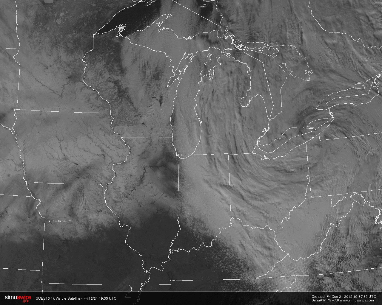
The trick to finding snow on a static satellite image? Look for the rivers. While clouds will obscure most surface features, snow on the ground means that unfrozen rivers will still be visible.
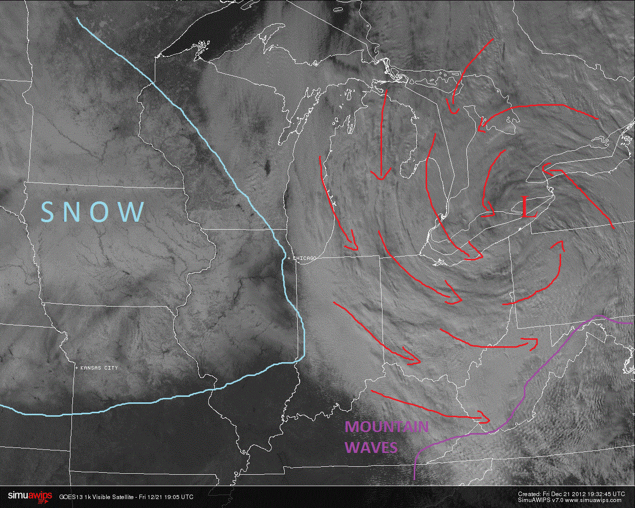
The winds rotating counterclockwise around the low are also creating another fun satellite feature – mountain waves. As the win in the lower parts of the atmosphere, especially in the lower few thousand feet, moves eastward across the Appalachians, it becomes more turbulent, and can begin to oscillate in an up/down manner. The vertical motion in the wind creates wavelike patterns in the clouds. They also propagate eastward even after crossing the mountains. In the image above, you can see they carry well east across Virginia.
Now that this low and cold front have moved through the region, we’re dealing with a relatively quiet pattern over most of the next week. There’s been some reports of snow flurries across the day today, but that’s likely the most snow that anyone will see outside of the high mountains of far southwest Virginia and West Virginia.
We’re stuck with the wind for one more day – gusts tomorrow will likely peak in the 30 mph range through the afternoon tomorrow. As the low I talked about above moves off to the northeast and into the Canadian Maritimes and beyond, the pressure gradient will ease off and winds will diminish accordingly later tomorrow.
Temperatures over most of the next week are going to hang out in the seasonable range over the next several days. Highs will run in the mid 40s to near 50 through Christmas Day. Lows will stay moderate through this time as well; the only real chance for temperatures to dip below the freezing mark will be late Saturday night and early Monday morning.
A weak system will cruise through the Mid-Atlantic over Christmas Eve and early Christmas Day. Cloudy skies will be predominant, and some brief periods of rain may pop up Monday night and before sunrise on Tuesday, with some sunshine returning later in the day.
The two days following Christmas have me concerned at the moment. The current model progression takes another system across the southern states and then transfers its energy to a developing low off the coast that will evolve into a nor’easter over the course of Wednesday and Thursday.
Here’s a look at the national forecast map for 7am Wednesday from the National Weather Service’s Hydrometeorological Prediction Center:
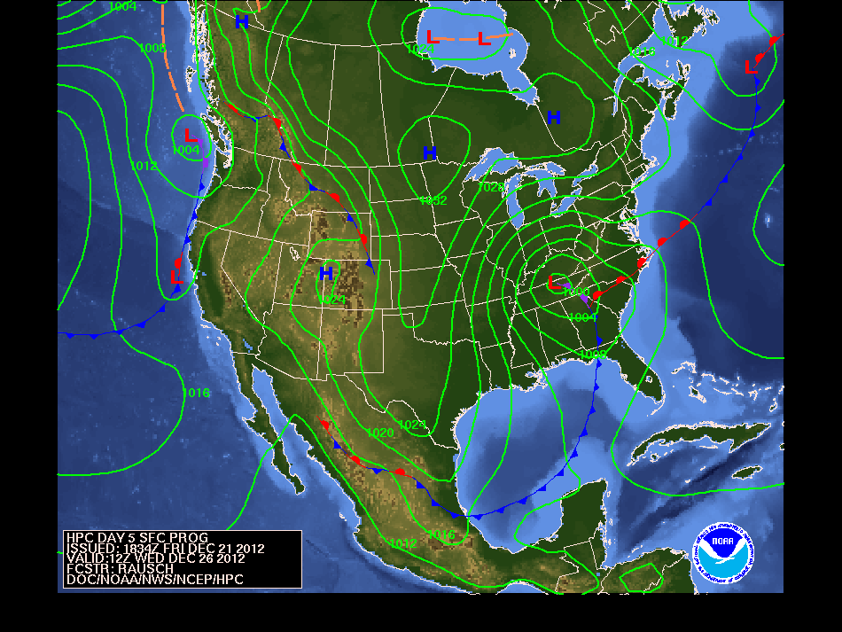
The key feature here is not the low itself but that bright red warm front extending east of the low. If we stay in the warm sector, then a majority of the precipitation we see will be of the liquid form (rain). However, there’s a lot more to this, and some of the features are a bit nuanced to elaborate at the end of a long post. We’re still five days out at this point, and I’d like another day or two of model runs before I really have a ton of confidence in what will come next week. I will say this – I would be very surprised if we did not see rain at some point during the system’s progression.
I’ll give this the full Weather Dan treatment closer to Monday – stay tuned.
-
Recommend this
on Facebook -

Report an error
-

Subscribe to our
Weekly Digest

Weather Dan
Dan Goff is now a two-time former Richmonder, having departed the River City yet again in favor of southwest Virginia, where he is working on degrees in geography and meteorology at Virginia Tech. Have a question about the weather or weather-related phenomena?

This article has been closed to further comments.