Mayo Island could be yours
Formerly it hosted a baseball stadium and boathouses, now it’s home to unused parking lots, a metal recycler, trash and the homeless.

Mayo Island easily ranks as one of Richmond’s most underutilized spots. Formerly it hosted a baseball stadium and boathouses, now it’s home to unused parking lots, a metal recycler, trash and the homeless.
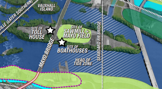
Word comes out today that the owners of the island are looking to sell. The property includes 4.6 acres upriver of the 14th Street Bridge, and 9.9 acres on the eastern side of the bridge. The island also figured into the Riverfront Plan and was envisioned as both a park and a connection between north and south of the river.
RTD has more details and the hurdles that face any type of development, mainly being in the middle of a river.
Most of Mayo Island is below the 100-year flood line, which makes zoning changes, especially for potential residential development, difficult from a regulatory standpoint.
The riverfront plan also notes that the floodwalls on both banks of the river are likely to make any future flooding on Mayo Island worse, as water would be kept off the north and south banks and pushed into the middle of the river.
Commercial development, according to the plan, would require building a secondary access route to the island that is higher than the current bridge and above the line of the 100-year floodplain. The island is also not hooked into the city’s sewer system.
Schwartz said he believes most development projects would require the construction of a second bridge.
The 100-year flood line is at a water level of 36 feet. The Mayo Bridge is at a level of 30 feet. According to Schwartz’s documents, which cite the National Oceanic and Atmospheric Administration, there have been two floods above 30 feet in the past 100 years.
Image: Riverfront Plan
-
Recommend this
on Facebook -

Report an error
-

Subscribe to our
Weekly Digest


There are 4 reader comments. Read them.