Weather! Near-record heat; more thunderstorms
There’s a threat for severe weather across central Virginia this afternoon and evening. Despite that, we’ve got some stellar weather in store for the second half of this week! The weekend’s not half bad, etiher.

It’s been quite the busy week so far – an unstable atmosphere has been responsible for several rounds of early-morning thunderstorms and some evening ones as well. That trend continues with the second half (3/5, I suppose) of the week.
The severe weather is a threat again this afternoon, as the Storm Prediction Center has highlighted most of Virginia as being as risk for severe weather.

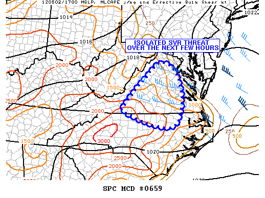
The biggest threats this afternoon will be storms with damaging winds and/or severe hail. Conditions near and east of Richmond aren’t as great as areas closer to the Blue Ridge, but the threat does still exist. The Storm Prediction Center has also posted this updated discussion:
MESOSCALE DISCUSSION 0659
NWS STORM PREDICTION CENTER NORMAN OK
1241 PM CDT WED MAY 02 2012AREAS AFFECTED…CNTRL VA…FAR N-CNTRL NC
CONCERNING…SEVERE POTENTIAL…WATCH POSSIBLE
VALID 021741Z – 021945Z
PROBABILITY OF WATCH ISSUANCE…40 PERCENT
SUMMARY…ISOLATED TO SCATTERED THUNDERSTORM DEVELOPMENT IS EXPECTEDOVER THE NEXT FEW HOURS. A FEW THUNDERSTORMS MAY PRODUCE SEVERE HAILAND STRONG WIND GUSTS. WILL CONTINUE TO MONITOR THE AREA FORPOSSIBLE WW ISSUANCE.
DISCUSSION…EARLY MORNING INVERSION HAS QUICKLY MIXED OUT ACROSSMUCH OF THE REGION. AS A RESULT…TEMPERATURES HAVE ALREADY CLIMBEDINTO THE 80S WITH SURFACE OBJECTIVE ANALYSIS INDICATING MLCAPEVALUES AOA 1000 J/KG. LATEST WV IMAGERY DEPICTS A SUBTLE DISTURBANCEMOVING ACROSS THE HIGHER ELEVATIONS OF WV. THIS DISTURBANCE ISEXPECTED TO INITIATE CONVECTION ALONG AND EAST OF THE APPALACHIANS.DEEP BOUNDARY LAYER MIXING AND AMPLE LOW-LEVEL MOISTURE SHOULDCONTINUE TO WARM/DESTABILIZE THE ATMOSPHERE EAST OF THE APPALACHIANSOVER THE NEXT FEW HOURS. ANY STORMS THAT DO DEVELOP SHOULD MOVE EWDINTO AN ENVIRONMENT FAVORABLE FOR SOME HAIL/STRONG WINDS. LIMITINGFACTORS INCLUDE WEAK SHEAR /0-6 KM BULK SHEAR AOB 30 KTS/ ANDSYNOPTIC SCALE HEIGHT RISES IN RESPONSE TO INCREASED RIDGING OVERTHE AREA. SHEAR IS SLIGHTLY BETTER ACROSS PORTIONS OF CNTRL/ERNVA…WHICH SUGGESTS A GREATER POTENTIAL FOR UPDRAFTORGANIZATION/PERSISTENCE IS THESE AREAS. HOWEVER… INSTABILITY ISWEAKER. REGARDLESS…MULTICELL THUNDERSTORMS WITH AT LEAST ANISOLATED HAIL/WIND THREAT ARE ANTICIPATED.
Wednesday: Temperatures will continue to climb this afternoon – we’re in the mid-80s now and probably won’t get much warmer, thanks to some cloudcover that’s starting to build in. The record high for both today, tomorrow, and Friday is 92 degrees. We won’t make it today, though. Look for additional cloud development this afternoon. Showers will begin to pop up after 5 or 6 this evening, and as I’ve mentioned, thunderstorms are possible through later this evening. Temperatures will slide back into the mid-60s tonight.
Wednesday Squirrelcast (vs. Bowie, 6:35pm): A great night for baseball, but go prepared for a possible shower or thunderstorm to disrupt the game. Temperatures will be in the low 80s at first pitch and near 70 by the 9th inning.
Thursday: Very similar to Wednesday. If the clouds can stay away, we may make another run at 90 and that record of 92. There’s the chance for showers/storms to develop again during the late afternoon and evening. Temperatures slip back into the mid 60s overnight.
Thursday Squirrelcast (vs. Bowie, 6:35pm): Again, similar to Wednesday’s game. Temperatures in the low 80s to start the game, closer to 70 by the time things wrap up tomorrow night. There’s the chance a stray shower or thunderstorm could delay things for a bit.
Friday: Slightly cooler on Friday, but temperatures will still run well above average for early May, peaking near 87. High pressure builds in from the south enough to minimize the chance of showers and thunderstorms. Lows overnight fall back to near 65.
Temperatures begin to cool off a little bit over the weekend with highs returning to near-normal, going from the low 80s on Saturday to the upper 70s on Sunday. Despite a chance of showers on Saturday, we should remain mostly dry. Overnight lows will stay in the 60s through the weekend.
-
Recommend this
on Facebook -

Report an error
-

Subscribe to our
Weekly Digest


Notice: Comments that are not conducive to an interesting and thoughtful conversation may be removed at the editor’s discretion.