Riverfront, Bicycles, Main Street Station: What’s up with City development plans?
Here’s what the city will look like next year…and beyond.
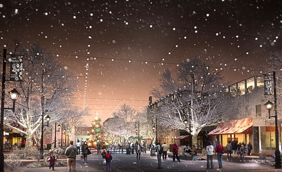
Rendering of future 17th Street Market courtesy of Baskervill
A map of Richmond stretches floor-to-ceiling in the library of the Department of Planning and Development Review, located on City Hall’s fifth floor. The aerial depiction gives Mark Olinger, the department’s director, a bird’s eye view of the city’s roughly 62.5 square miles along with its roads, bridges, and parcels.
He sees potential.
“We have the ability to be one of the absolutely great mid-size cities in America,” Olinger said one recent afternoon. “And I think there’s an energy here that can help us get there over time.”
Olinger is often the point man for major city projects: the City’s master plan, Riverfront Plan, and even down to specific neighborhoods. He and other officials pore over these plans–which touch on zoning, infrastructure, development, etc.–on an almost daily basis.
But while City officials engage with these plans regularly, it’s easy for residents, who don’t get behind-the-scenes access, to wonder: “Hey, wasn’t the City supposed to be working on this_?” or “Hey, whatever happened to that?”
So here’s a recap of major plans and projects: where they are, where they’re going, and what they might mean for the city’s future.
— ∮∮∮ —
Master Plan
Perhaps the most important plan the city has at any given time is its master plan, which typically guides policy for 20 years.
“Occassionally, you need to take a step back and think about the city as a whole and…think about some of the larger trends that are happening,” Olinger said.
It’s been nearly 15 years since the city’s master plan has been fully updated. “Richmond is a very different city now than it was in 2001,” Olinger said. “For the first time in a very long time, we’re actually growing in population.”
According to Olinger, there were roughly 250,000 residents in the city in 1970. In 2000, that number dropped to 197,000 (roughly 53,000 people).
But in 2010, the Census put Richmond’s population at just over the 200,000 (Olinger said he’s heard estimates around the 212,000 mark).
“So the question is, if we continue to grow and if people continue to find Richmond an interesting and desirable place to live, how and where do we accommodate that growth? How do we plan for things like new infrastructure…new facilities?” he said.
The city’s population boom and growing cultural identity means people are thinking about what Richmond looks like and what it should look like. “It’s an important time to have that conversation,” Olinger said. “A master plan update will help determine how we look” at things like zoning, capital improvement projects, schools, etc..
He expects that within the next few years, City officials and residents will look over updates to the master plan — which must be approved by both the Planning Commission and City Council — with keen interest.
Riverfront Plan (PDF)
Adopted in late 2012, the Riverfront Plan sought to reimagine Richmond’s relationship with the James River. Next year, construction will begin on the most visual component of the plan to date: the Brown’s Island Dam Walk, known as the T. Tyler Potterfield Memorial Bridge.1
“That’s a big project. It’s putting the bridge back in across from Brown’s Island to the Southbank,” Olinger said. The bridge will rise roughly 17-feet above the water, have bike lanes, and will be accessible 24 hours a day, Olinger said. “The idea of how people will be able to use that will be transformative.”
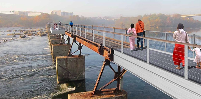
Rendering of the T. Tyler Potterfield Memorial Bridge
Nearly $10 million has been procured over the last two budget rounds to help fund Riverfront Plan projects. That money is a relative drop in the bucket compared to the estimated $70 million it would cause to implement all aspects of the Riverfront Plan. But Olinger preaches patience. “It doesn’t have to happen all at once.”
Avoiding a construction blitz that would see the entire plan realized at once has benefits. “The plan may morph and be amended occasionally as people experience the water differently,” Olinger said. If that happens, he said, the plan should be flexible. “As more people begin to use [the James River or any property]…things may become apparent that we hadn’t thought about. And I think we should have the ability to make changes when they become apparent,” he said.
To that point, there’s the possibility of Vauxhall Island getting a new owner in the near future, and Mayo Island is once again for sale. Their fates may change how people feel (or want to feel) about the River, which could motivate updates to the Riverfront Plan.
But no matter what shakes out, Olinger said the Riverfront Plan will remain a vital part in shaping the city’s identity. “The value of the riverfront to the city in bringing more people back to the water will spell huge benefits for the city long term,” he said.
Two projects to look forward to
Main Street Station

Main Street Station train shed rendering (via SMBW)
Jeanne Welliver doesn’t mince words about it.
“It is the grandest piece of architecture from here to Miami along I-95 and it’s pretty much the last urban market along I-95 until you get to Jacksonville, FL” Welliver, project director of the Shockoe Economic Revitalization Strategy (PDF), said about Main Street Station. “If you take the Eiffel Tower out of Paris, what would it do to Paris?” she said.
“This our Eiffel Tower and we want to capitalize on it.”
Having refurbished the clock tower rising next to I-95 traffic (Phase 1 – 2003) and acquired and redeveloped the land across the station’s Main Street entrance (Phase 2 – 2007), Phase 3 is now underway inside the station’s train shed. “We are going to turn it into a welcome center unlike anything in Virginia,” Welliver said.

Train shed interior rendering (via SMBW)
Roughly $46 million of the total $86 million in public funds raised to redevelop the historic train station will go to dramatically reimagining the train shed and surrounding area in a project designed by local firm SMBW.
Workers have already removed the six freight car rail lines from the 80,000-square-foot second floor shed built in 1901.4 “We’re keeping the building incased in its corrugated metal, so you can’t really tell that anything’s is going on,” Welliver said. “But that second floor has been totally removed…[but] the historic black riveted steel5 remains. That’s the only thing that will remain because that’s the only thing original to 1901.”
In Spring 2015, workers are scheduled to remove the corrugated metal and roof. “That’s when the dramatic transformation will be seen,” Welliver said. Workers will then install a new roof and glass walls (making the interior visible to motorists on I-95), which allow for commercial tenants, as well as an indoor market. Welliver said the City has been speaking with potential commercial tenants. “We’ve been working on that for many years with the Mayor’s Office. We just don’t have a concrete rollout yet planned,” she said.

Train shed exterior rendering (via SMBW)
When the train shed project opens (the goal is Summer 2016), the venue will incorporate surrounding bicycle6 and pedestrian trails, Amtrak trains, and busses for a multi-modal transportation hub and visitor center. “We want this to be a daily supported, weekly supported place by the region and local community. We also want it to serve as a tourism welcome center. So it plays two roles,” Welliver said.
The project also involves resetting the nearby roads. “We want to restore the grid pattern to connect Shockoe Bottom and Church Hill back to the central business district and Capital Square like it originally was,” Welliver said. In addition, parts of Franklin Street near the train station will be redone for pedestrian-only traffic in time for train shed’s opening in late 2016.
17th Street Market
It was the public square in the late-1700s and 1800s for both the city and the region. Soon the 17th Street Street Market will also get a dramatic face lift.
When discussing Shockoe redevelopment with residents in 2010, Welliver said the City heard from locals a call to remove the outdoor structures within the square, open it up, and return it to its public square origins. “And that’s exactly what we’re working on,” Welliver said.

17th Street Market rendering (via Baskervill)
The City has tapped local firm Baskervill to design an open, dynamic 17th Street Market. Welliver said she has a cost estimate for the plans, and will soon go before the City Planning Commission to present plans for the market’s redesign and future maintenance. On Monday at 5:30 PM, the City will join the Shockoe Bottom Neighborhood Association at a meeting updating nearby businesses and residents of current plans.
Both the 17th Street Market construction, as well as construction on land adjacent to the train shed, won’t begin until after next September’s 2015 UCI Road World Championships. “We don’t want to tear up the surfaces when we have guests coming from around the world,” Welliver said. “After the bike race, we will also tear up the Main Street Station site to allow for an improved site layout to accommodate multi-modal transportation, the visitors center, guest parking…and things like that.”
Anticipating both the 17th Street Market and train shed redevelopment projects to finsish in late 2016, Welliver imagines they’ll become the “welcome mat for the city.”
Bicycle Master Plan
With its official adoption expected sometime next year, the Bicycle Master Plan will “certainly fit in how we think areas grow and develop,” Mark Olinger said. The City and consulting firm Alta are now scrutinizing the final draft of the plan.
Max Hepp-Buchanan, director of Bike Walk RVA, is one of the few people outside City Hall that’s been following the plan throughout its drafting stages.
“It’s a good blueprint for us going forward to figure out how and where we make the city most bike friendly,” Hepp-Buchanan said. “There are a lot of different facility types,7 some of which offer more protection for cyclists than others. So there are plans for protected bike lanes downtown on Main and Franklin, and I believe on 8th and 9th, which will be the first in Richmond and definitely the type of infrastructure that we need to get people feeling safe and comfortable through downtown.”
The plan also highlights bike-walk streets, the first of which is now being planned to run along parts of Floyd Avenue. “I think these are really important because they are low speed, low volume neighborhood streets that give people that feeling of confidence and comfort…” Hepp-Buchanan said. “Our job from here is to really define what a bike-walk street is so that there’s consistent elements as they’re implemented.”
Just like Mark Olinger, Hepp-Buchanan said city plans (like Bicycle Master Plan) should be a living document that can adapt and change when needed. “There are lines on a map in the Bicycle Master Plan that provide us with that blueprint, but that’s not to say those lines can’t be moved one street over or a couple streets over or be a change in facility type based on the needs of the residents in that area,” he said.
Finalizing and adopting the Bicycle Master Plan doesn’t mean the contents of plan magically appear. “The key piece that we need once the plan is adopted is funding to implement the plan,” Max-Buchanan said, adding that funding shouldn’t be hard to come by “once decision makers at the city understand this is a 10-plus year plan, and we’re really only into year one of implementation.”
The upcoming UCI bike race puts a large gust of wind in the sails of bicycle advocates. But the plan will need support long after international eyes turn away from Richmond. “It’s important to fund the plan so we can build out more and more of it each year,” Hepp-Buchanan said.
VUU/Chamberlayne Neighborhood (PDF)
About two years ago, officials at Virginia Union University were finishing up work on the university’s own master plan. Olinger recalls those officials approaching the City and asking: “What’s the interaction between us and the surrounding industrial area? What happens with Lombardy and Chamberlayne?”
They were great questions, Olinger said, and ones that need to be considered.
Lombardy and Chamberlayne, the main roads near VUU campus, are primarily designated B-3, a type of commercial zoning. “The zoning tends to lend itself to these auto-oriented uses in an area where you’d really want to be driving pedestrians and bicycle enhancements,” Olinger said.

Intersection of Lombardy Street and Brook Road

Rendering of intersection at Lombardy Street and Brook Road
The VUU/Chamberlayne plan aims to make the area less industrial and more of a livable neighborhood with shops, restaurants, housing, green spaces, and bicycle lanes.
“There are very positive things happening over there,” Olinger said. “It’s just how [do you] get people thinking about what that area could become?
After several public meetings and internal City discussions in recent months, the VUU/Chamberlayne Neighborhood Plan could go before the Planning Commission and City Council for approval as soon as early 2015. Once approved, specific projects could start to come to life.
Hull Street Corridor (PDF)
Finalized in early 2013, in partnership between the City and Chesterfield County, the revitalization plan for a 4.7-mile stretch of Hull Street reimagines the corridor’s place and personality in the region.
Olinger said that before the Interstate System arrived in cities, roads like Hull Street connected city residents to the suburbs. These roads were perfect for commercial development in a culture becoming more and more car centric. Planners of that era thought: “Stores want lots of parking, so we’ve got to figure out places where we can put places with lots of parking,” Olinger said. “I think you see that in a lot of those areas” like Hull Street.

Rendering of revitalized intersection of Hull Street and Warwick Road
As such, there aren’t many inherent options for pedestrians and bicyclists. “The plan says there’s potential, but there’s a lot of infrastructure work that needs to be done,” Olinger said. The City’s Public Works department is developing specific projects to bolster the area’s sidewalks, curbs, streets, etc.
Olinger said the corridor has select “nodes” (i.e. intersections) of activity that could inspire future growth: Belt-Hull, Chippenham-Hull, Warwick-Hull.
Much of Hull Street’s revitalization depends on new zoning. The current zoning, as described in the plan, fosters “low-intensity, land inefficient, auto dominated uses and building forms that will not create synergy and promote growth.”8
Olinger: “The idea is: how do we create opportunities for, perhaps, more mixed use? Maybe some of those areas become more housing than commercial.” He said provisions for affordable housing have been discussed, as have incentives for home ownership in the area.
But improved infrastructure and better housing opportunities may not be enough. At least right away. “Sometimes you can get the infrastructure done sooner, but getting people to think differently about an area sometimes takes a longer time horizon,” Olinger said.

Rendering of Goodes Bridge Square
- See page 25 (PDF). ↩
- See page 37 (PDF). ↩
- See page 48 (PDF). ↩
- Builders elevated the train shed when it was built in 1901 to withstand flooding. ↩
- “It’s one of the first examples of riveted steel connections in the United States,” Welliver said. ↩
- For instance, the Capital Trail will connect with the station. One idea is to provide shower stalls and parking to accommodate bicyclists. ↩
- The San Francisco Municipal Transportation Agency has a good breakdown of what “facility types” can be. ↩
- See page 133 (PDF) ↩
-
Recommend this
on Facebook -

Report an error
-

Subscribe to our
Weekly Digest

Nathan Cushing
Nathan Cushing is a writer, journalist, and RVANews Editor.

Notice: Comments that are not conducive to an interesting and thoughtful conversation may be removed at the editor’s discretion.
An excellent and informative article, Nathan. Nice work!
Nathan great article for those of us who wonder what’s going on. As a commuter and former resident of Richmond City I sincerely enjoy hearing positive things the city is doing. However, what is this city doing about the horrible road conditions. If this government wants to attract businesses and new residents it needs to address it’s failing road system. Just a few on the list in downtown….18th St, Canal St, Cary St. These roads are main arteries for commuters and daily residents and they are dilapidated. This isn’t the field of dreams where “if you build it, they will come”…the city needs to also focus on the basics….something the govt has failed on for many years.
Amtrak….not Amtrack. Also wouldnt the tracks under the shed have been passenger tracks, not freight?
Amazing plans…this is a riverfront city I would want to visit again and again. What a different impression our city would have made if some of these projects had been completed for the thousands of people coming for the bike race to enjoy and to be showcased as a destination. Seems backwards when you consider the empty storefronts, limited river access, and ragged marketplace they’re actually going to see…
Mike Smith: http://www.richmondgov.com/PublicWorks/StreetMaintenance.aspx
In the past the City has published a paving schedule, I don’t see one for 2015 yet. If you email or call, DPW usually answers questions about specific streets.