Weather! Severe weather Friday, Saturday gives way to Monday scorcher
Severe weather early this weekend gives way to the three amigos – hazy, hot, and humid – by Memorial Day. Have you had your air conditioning checked yet?
It looks like the severe weather has followed me back from my excursion to the Great Plains.
Before we get into that, here’s a reminder that the Atlantic hurricane season is just around the corner, beginning on June 1. This week is National Hurricane Preparedness Week. The Virginia Department of Emergency Management is sponsoring a Sales Tax Holiday through May 31. Here is a complete list (PDF) of exempt supplies, which includes alkaline batteries, bottled water, and weather radios.
Tangential to that (and appropriate with the start of the Memorial Day weekend) is that this week is also National Safe Boating Week. It’s just as important to be weather-aware on the water as it is on shore. Please be careful!
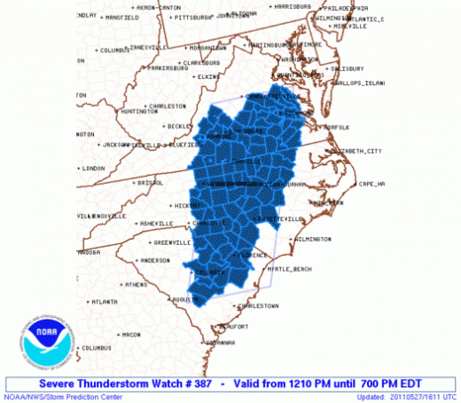
Speaking of severe weather, a Severe Thunderstorm Watch is in effect for the region until 7pm this evening.
Storms have been firing for some time now in the Carolinas and are beginning to cross into Virginia. The primary threats with these storms will be hail up to 1.5” in diameter (ping pong ball size) and wind gusts up to 70 miles per hour.
Cloudy skies are keeping temperatures down this afternoon, but Friday highs may still creep up another degree or two as we reach the period of peak heating for the day. The chance of thunderstorms will continue through this evening, with lows in the upper 60s.
We’ve got another threat of thunderstorms on Saturday, as afternoon temperatures make it back into the mid 80s. Unstable air remaining in the wake of today’s storms, along with exceptional afternoon heating, should create some additional popup showers and thunderstorms tomorrow. The threat of severe weather isn’t as great, but it still exists. Overnight lows again will fall into the upper 60s.
The storm threat leaves, but the heat stays on Sunday, sending temperatures back into the upper 80s under partly cloudy skies. The atmosphere will stabilize in the wake of thunderstorms from the two prior days; as that happens, the thunderstorm threat for Sunday appears to be minimal at best. Overnight lows will drop into the upper 60s to near 70 again.
Finally, the heat returns in full force for Memorial Day. The three “h”s – hazy, hot, and humid – make their triumphant return, with highs in the lower 90s. Monday’s record high is 98 degrees, and The Hardest Thing* to do will be breaking that record. I just don’t see it happening.
Highs in the nineties are looking likely well into next week. I’ll have another forecast update on Tuesday. Enjoy your weekend!
*If you saw what I did there, consider it your reward for reading all the way through.
-
Recommend this
on Facebook -

Report an error
-

Subscribe to our
Weekly Digest


Notice: Comments that are not conducive to an interesting and thoughtful conversation may be removed at the editor’s discretion.