Weather! Severe weather threat this evening; cooldown on the way
Looking at the chance for some more severe weather this evening, followed by a very noticeable cooldown starting tomorrow. The long-range models are even hinting at a possibility of some…other…precipitation early next week.
After a Monday that was bookended by thunderstorms, we got a brief reprieve yesterday. Unfortunately, an even bigger thunderstorm threat exists for today – especially this evening.
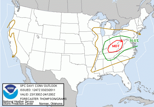
The Storm Prediction Center has most of Virginia under a slight risk of severe weather through this evening. A system currently developing over the Ohio Valley will swing eastward later today, with storms already beginning to fire between Charleston, West Virginia and Wilmington, Ohio.
As these storms get organized this afternoon, you’ll likely see what’s called a bow echo – a fast-moving line of storms that forms a bit of a curved, bowing shape. The biggest threat with systems like this will be strong winds along the leading edge of the bow, and the possibility for some large hail, both threats that the SPC has highlighted today.
There may be a small, isolated tornado threat with this system as well, and people should remain vigilant no matter. However, the biggest threats with this system will be the potential for damage from strong, straight-line winds and possible hail.
The Ohio Valley looks like they will take the brunt of this system, as it gets organized over the next hour or two. Timing is looking to be such that we won’t see anything across the mountains until later this afternoon, though an early area of showers is a couple hours away the Virginia highlands now. The bulk of the storm activity will come later this afternoon across the Virginia mountains and then later this evening closer to Richmond – likely after sunset. A lot of the low-level cloudcover seems to have broken up, and the heating from the extra sunshine will provide a little extra fuel for this evening’s action.
For the remainder of Wednesday, we’re looking at quite a nice day. Highs will hopefully still get into the upper 60s to near 70, before cooling down this evening. After the storms clear out, we’ll see overnight lows right near 50.
The cold front that is crossing the Ohio Valley now and is the trigger for today’s severe weather has a pool of cold air behind it that will keep temperatures much cooler for the rest of the week. Temperatures Thursday will only reach the low 60s, and we’ll see the rarefied 30s as lows that night.
The cooldown will continue through Friday and the weekend, with temperatures almost 10 degrees below the average for this time of year. I’m looking at another rain chance over the weekend, following by the possibility (be it ever so small – and it is quite small) for some snow across the region in the early part of next week. We’re still almost a week out, and the signals for snow at least around Richmond aren’t very strong, so please take that with a grain of salt at this point. I’ll keep an eye on the trends and keep you posted, however. Look for another update Friday morning.
-
Recommend this
on Facebook -

Report an error
-

Subscribe to our
Weekly Digest


There are no reader comments. Add yours.