Weather! Hot…and then not.
Near-record high temperatures and elevated fire danger today, severe thunderstorms tonight, and a 40-degree temperature swing by tomorrow night. Just another two days in Richmond weather.
It’s been rather warm since last night, as evidenced by an overnight low of only 50 degrees at RIC at 1am, far earlier in the night than would normally be expected. The reason for this was a warm front that passed through overnight, which will send temperatures soaring today.
It’s Monday, so it’s only so great to begin with, so as far as weather goes, we’re looking at an absolutely fantastic day. Thanks to the warm front, we’re going to see high temperatures in the low 80s today, and if these high cirrus clouds overhead give way, we may even go a tick or two higher. Today’s record high is 86, and while I don’t think we’re going to meet or beat that, we may come within a few degrees. Skies should remain partly to mostly clear all day, but breezy, as winds this morning have been out of the southwest around 15 miles per hour. With gusty winds and relatively dry air, we’re in an area of increased fire danger today. Please use care when doing any outdoor burning, and remember that Virginia law prohibits outdoor burning before 4:00pm until April 30.
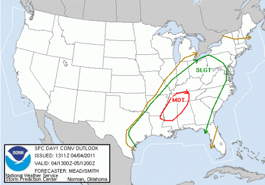
We’ve also been highlighted as part of a slight risk area for severe weather today by the Storm Prediction Center.
Specifically, the SPC is looking at the threat of strong to severe thunderstorms with damaging wind gusts into the evening and overnight hours tonight. For those of you with small children, I apologize now; it may be a long night for some of you. As we continue to stay in the warm sector tonight, we’ll have overnight lows that only drop into the low 60s tonight. Don’t get used to that just yet.
The trigger for these thunderstorms will be a cold front passing through the region tonight and tomorrow morning. Depending on the exact timing of the front, this severe thunderstorm threat may continue for the eastern portion of Virginia – most likely those east of I-95 – into tomorrow morning. We’ll reach our Tuesday high of 65 early in the morning, and temperatures will continue to plummet through most of the day, finally bottoming out near 40 tomorrow night. High pressure behind the cold front means we’ll see any clouds start to clear out after the front passes, as well.
Temperatures moderate somewhat later in the week, with highs quickly bouncing back into the 60s and 70s later this week. I’ll have another update Wednesday morning.
-
Recommend this
on Facebook -

Report an error
-

Subscribe to our
Weekly Digest


Notice: Comments that are not conducive to an interesting and thoughtful conversation may be removed at the editor’s discretion.