Weather! Clear early, rain later this week
It figures that the one Monday I’m running super-late is the one where I’ve got a ton to write about. Joyeux Lundi, tout le monde!
It figures that the one Monday I’m running super-late is the one where I’ve got a ton to write about. Joyeux Lundi, tout le monde!
I reported last week that the October “bomb” had unofficially set a record for the lowest pressure not associated with a tropical cyclone to be recorded within the lower 48 states. The National Weather Service office in Duluth, Minnesota wrote up an excellent summary of the storm, including its impact on pressure records.
Bigfork, Minnesota (KFOZ) recorded a minimum sea level pressure of 955.2 millibars (or 28.21” of mercury), which sets a new state record for Minnesota. Wisconsin (961.3 millibars) also set a state record at Superior. Despite setting two state and several local records, the storm did not set a national record. The lowest pressure ever recorded in the United States was 892 millibars, recorded at Matecumbe Key, Florida on September 2, 1935 during the Labor Day Hurricane. The lowest pressure recorded in the US not as a result of a tropical cyclone/hurricane was 927 millibars on October 25, 1977 at Dutch Harbor, Alaska. There are apparently several possible record-holders for lowest non-tropical sea level pressure in the lower 48 that cannot be verified through historical data; the lowest recorded sea level pressure that can be verified is a measurement of 955.0 millibars, which has happened twice: once on January 3, 1913 at Canton, New York, and again on March 7, 1932 at Block Island, Rhode Island. We missed setting a record by two tenths of a millibar.
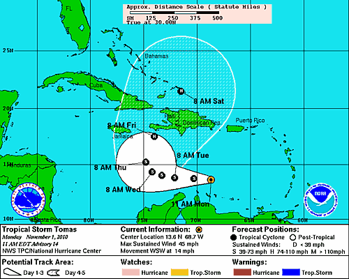
Speaking of tropical cyclones, Tropical Storm Tomas developed over the weekend in the Carribbean. Tomas was originally forecast to develop into a major hurricane later this week, but that forecast has been revised downward as the atmosphere around it features a lot of high wind shear and dry air, neither of which are conducive to tropical development.
The forecast track for Tomas takes it on a northward turn later this week; the same mechanism that will cause that jog to the north will also be responsible for a more favorable environment for intensification, and Tomas should be back to hurricane strength by the time it reaches Haiti and the southern Bahamas.
An area of high pressure is keeping the skies over Virginia mostly cloud-free today. The remainder of Monday should be the same, with highs only in the mid 50s today. Unseasonably cool temperatures will continue overnight, with the possibility of temperatures near freezing, and the possibility of maybe some scattered frost in a few places early tomorrow morning. Overnight lows should fall into the upper 30s.
As for Tuesday, the strong high over the Great Lakes means more of the same, with continued cool temperatures. Pretty much a carbon copy of Monday, with highs in the mid 50s and lows in the upper 30s, with the chance of some patchy frost in cooler locations.
As we get closer to midweek, the models are supporting the development of a coastal low off the VA/NC coast. The resulting nor’easter looks like it may be a decent rain event for later this week, with rainfall amounts in excess of an inch along the eastern part of the state. If you’re heading out to Blacksburg for Thursday night’s game against Georgia Tech, make sure to pack a poncho. I’ll have a complete update on Wednesday, including a forecast for Thursday night.
-
Recommend this
on Facebook -

Report an error
-

Subscribe to our
Weekly Digest


There are no reader comments. Add yours.