How Jarrett Walker and Associates will show us the future of mass transit in Richmond
Like, the very near future. This consulting firm has stepped in to help us figure out exactly what our options are.

Photo by Michael Chronister
So the City and the Greater Richmond Transit Company would like to make a baby, and that baby is a functional transit system that serves contemporary population needs. Hopefully they’ll come up with a better name before you try to embroider that on a bib.
But what about the Bus Rapid Transit system? The plan that Council already passed? That’s set in stone, now, and the reorganization of the bus system around it is the next logical step.
The City knows a lot about what’s going on with the City (one hopes), and the GRTC knows a lot about buses. That’s two huge players who are looking at things from different angles. And sometimes big players need a little help from an outside source–a source with a valuable outside perspective and a portfolio of cities he has helped that will make you gulp in an intimidated way.
Meet Jarrett Walker, everybody!
We sat down with key members of the Jarrett Walker and Associates team last week during a break in their “core design retreat.” The retreat, which involved representatives from the City and GRTC, gives everybody a chance to sit around a table and really hash out what their groups want and need. The result is a choice report, which will tell us what our transportation revamp options are based on geography, geometry (we’ll get to that), and priorities. It’ll be all over the spectrum, giving us a good visual on the range of possibilities–concepts that aren’t necessarily recommendations. The idea is for us to be able to see what all these options could look like, no matter whether or not they’re a good idea.
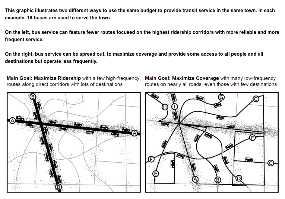
According to Walker, most conversations around restructuring a transportation system really come down to one thing: a tension between serving areas that would bring the most ridership and areas that have the most need. At first read, you probably thought those were the same, but in reality they’re two separate circles of a Venn diagram. There’s overlap sometimes, but there could easily be a bus route that serves just a few people with a greater need than a more densely populated area who’s doing OK with their cars right now.
Walker’s suggestion is for cities to figure out what portion of their transportation budget should go to maximizing ridership, and what portion should go towards meeting coverage goals. That roadmap will help clear up other decisions. After a plan has been finalized, the target date for implementation is 2017, coinciding with the BRT’s launch.1
“Every city is unique in a way that makes it interesting,” says Walker, who along with his team have been scrutinizing our Very Richmond terrain, layout, existing infrastructure, and needs since January. That’s not a ton of time, when you think about it, but they’re comfortable working on a tight schedule.
And while cities are all wonderful snowflakes, geometry poses the same problem in each of them:
Cars take up more room than people.
It’s really simple–if you live in a building of six apartments that houses, say, 10 people, you’d need a huge chunk of your block in order to accommodate that many cars. It’s hard for me to grasp with my brain, but some people even own more than one car per person in their family. When a city gets to a certain density, a car-based transportation system just isn’t as practical as it once was.
So here we are, in a city that is lucky to have a large walkable area (larger than any other Southern city Walker could think of) put in place before World War II and the mass transit boom that happened afterwards. We were a horse-and-carriage city, an electric trolley city, and then we were a car city. The freeway construction chopped up neighborhoods, and the river provides a psychological but also physical barrier between others.
But Walker and co. don’t necessarily have to take on the weight of our politically-charged history. They have the luxury of looking at where things are now and helping us get to where we want to be. “We do ask not to be burdened by history,” says Michelle Poyourow, Senior Associate, who has learned so much about how the past has brought us to the present anyway in the last four months that I’m ready to write her in for mayor. It’s not easy to ignore it, though, especially since the nature of their calling makes the whole Jarrett Walker team naturally curious as to how things got from point A to point B.
“We look at different ways to frame the conversation,” says Walker. “It’s easy for people to get distracted [by history].”
“A lot of transit happens one neighborhood at a time,” adds Poyourow. “But looking at it city-wide transforms [the vision] on a scale that benefits each neighborhood. Then all of those little battles take on different meanings.”
The present is an interesting time for a third party to try to wrestle all of our moving pieces into order–what with a new Mayor and potentially new City Council coming on board early next year. But, there’s always something happening in a city they’re working on, says Poyourow, adding that it’s really the community buy-in that’s their goal. It’ll be critical, they both agreed, for a blueprint to emerge from this report that shows a redesign that’ll be beneficial to the public. And that’s why public interest has been their focus from the beginning, with a survey that itself helps explain what kind of factors go into these decisions.
What follows is an actual screenshot from that survey!
The counties, by the way, are not included in the choice report. They’re the ones taxing their residents, says Walker, so they’re entitled to make their own decisions, namely what they want from mass transit.
The next series of public meetings will be in July and August, and perhaps more than we have ever before, we urge you to attend. You will learn so much, and your armchair urban planning may just elevate itself to, like, “more authoritative chair.”
- The regional plan–of which this study is a part–plans for the next 20 years. The City is keeping the not-so-immediate future in mind as well. ↩
-
Recommend this
on Facebook -

Report an error
-

Subscribe to our
Weekly Digest

Susan Howson
Susan Howson is managing editor for this very website. She writes THE BEST bios.

Notice: Comments that are not conducive to an interesting and thoughtful conversation may be removed at the editor’s discretion.
When Walker says that Richmond has the largest “walkable area” among Southern cities that he’s seen, what does that mean? Sidewalk? Parks? I’m curious. Thanks!
Walker’s book “human Transit – How clearer thinking abut public transit can enrich our communities and our lives’ is a great and very practical read. I love what he says about how transit helps pedestrian life and vice-versa. I am also curious about Josh’s question about Richmond’s alleged walkability. I agree but I’m not sure we are a very walking oriented community. I look forward to participating in a monthly book club to discuss this book with a group called RVA Rapid Transit.
@Josh: It means that we have a pretty tightly packed map of residents/businesses, i.e. you could potentially walk to a bus stop. Farther-spaced areas (like the further you get out in the suburbs) makes an area less walkable.
As part of the team, I can try to clarify the interpretation of walkable area. What I believe Jarrett meant is that compared to other southern cities, Richmond had a larger area developed before World War II (the beginning of the auto dominated era) and the pattern in the areas developed prior to the war trends to have a density and development style that is walkable (gridded and connected streets, sidewalks, shorter blocks). Hopefully that clarifies things a bit.