UPDATED: Severe weather possible overnight; tornado watch until 2 a.m.
A strong cold front responsible for severe thunderstorms across 10 states is making its way toward Virginia. There’s a slight risk for severe thunderstorms tonight and strong winds capable of damaging homes and other property.

Update #2 — January 30, 2012; 8:33 PM
This system has been very slow to cross Virginia today, but has finally begun to reach the fringes of the Richmond metro area.
To wit, the Storm Prediction Center has issued a Tornado Watch until 2:00 a.m. for the entire metro area.
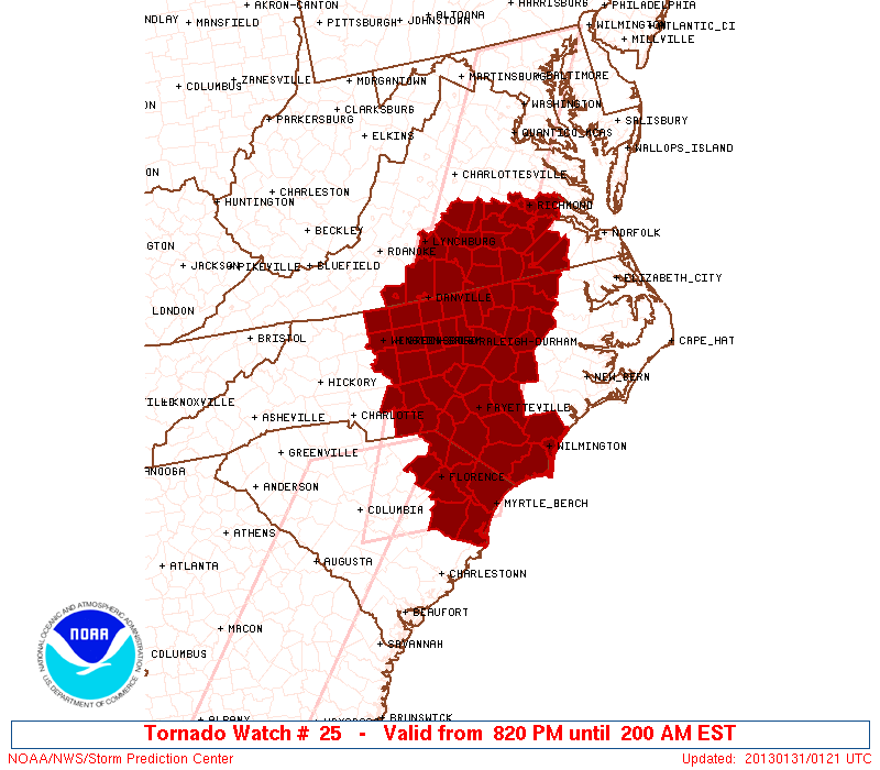
TORNADOES…HAIL TO 0.5 INCH IN DIAMETER…THUNDERSTORM WIND GUSTS TO 75 MPH…AND DANGEROUS LIGHTNING ARE POSSIBLE IN THESE AREAS.
[…]
REMEMBER…A TORNADO WATCH MEANS CONDITIONS ARE FAVORABLE FOR TORNADOES AND SEVERE THUNDERSTORMS IN AND CLOSE TO THE WATCH AREA. PERSONS IN THESE AREAS SHOULD BE ON THE LOOKOUT FOR THREATENING WEATHER CONDITIONS AND LISTEN FOR LATER STATEMENTS AND POSSIBLE WARNINGS.
— ∮∮∮ —
Update #1 — January 30, 2013; 2:40 PM
Here’s an updated wind hazard assessment from the Storm Prediction Center:

The squall line continues to march eastward; multiple tornadoes were reported yesterday, as have several fatalities. Showers will begin to develop ahead of the line across central Virginia later this evening, in the 8:00 – 9:00 PM timeframe. Strong winds are still a concern tonight; the squall line won’t pass through the area until after midnight. As I mentioned earlier, I don’t expect to see any sort of widespread power outages, but don’t be surprised if yours does blink out.
— ∮∮∮ —
Original — January 30, 2013
Yes, it’s January 30th.
Yes, temperatures have been above 60 degrees all night long.
Guess what? You’re going to get one more day of this unseasonably warm weather. Unfortunately, it’s going to come with overcast skies and a healthy wind for most of the day. By midday, the wind will continue to pick up, with gusts of 30-40 mph possible beginning later this afternoon.
All of this is occurring in advance of a very strong cold front that’s produced severe weather from Texas to Indiana and Kentucky over the last day, including multiple tornado reports and widespread wind damage.
Tonight that same system shows up on our doorstep.
The map below is the severe weather outlook published by the Storm Prediction Center in Norman, Oklahoma. Virtually the entire state faces a slight risk for severe thunderstorms today:

This second map is an outlook strictly dealing with severe wind–winds in excess of 58 mph. The 15% and 30% regions that cover Virginia represent relatively significant values, especially for this time of year.

There is some uncertainty still regarding exactly when the front will arrive, whether or not any showers will develop ahead of the front, and what kind of shape the system will be in when it gets here. That said, the potential is there for a rather stormy evening tonight.
Right now it looks like the line will make its way into the metro area later in the evening, likely after 7:00 PM.
This is actually a good thing; the system will be passing through eastern Virginia without of the benefit of the sunlight to heat things up and destabilize the atmosphere any more. This may limit how much damage we see, especially from things like trees being blown over. Yes, the ground is pretty saturated after all the rain and snow from the last couple weeks, but between Hurricane Irene in 2011 and the derecho last June, much of the at-risk vegetation has already been blown over or identified and removed.
Will there be power outages? I’d be surprised if there weren’t. Will there be big citywide outages like we saw in Irene and the derecho? I highly doubt it. Regardless, if you do encounter severe weather today, get you and your family to a safe shelter.
At any rate, keep an eye on conditions today. I’ll update things here as conditions evolve today and we get in some of the morning model runs.
-
Recommend this
on Facebook -

Report an error
-

Subscribe to our
Weekly Digest

Weather Dan
Dan Goff is now a two-time former Richmonder, having departed the River City yet again in favor of southwest Virginia, where he is working on degrees in geography and meteorology at Virginia Tech. Have a question about the weather or weather-related phenomena?

Notice: Comments that are not conducive to an interesting and thoughtful conversation may be removed at the editor’s discretion.